2022 Undergraduate Scholarship Winner
Lucy Roberts
NACIS was pleased to award the 2022 NACIS Undergraduate Student Scholarship in Cartography to Lucy Roberts. Lucy is a spatial data science major with a minor in global health at the University of Oregon’s Clark Honors College. She’s an employee of the UO Infographics Lab where she helps perform geospatial data analyses and create visualizations for a myriad of research partners. She spent the last summer developing her skills in programming and data visualization as a product engineering intern with Esri’s ArcGIS for Adobe Creative Cloud team. She is interested in the ways GIS can be used to promote equity, and was named an Oxford University Human Rights Fellow in 2022.
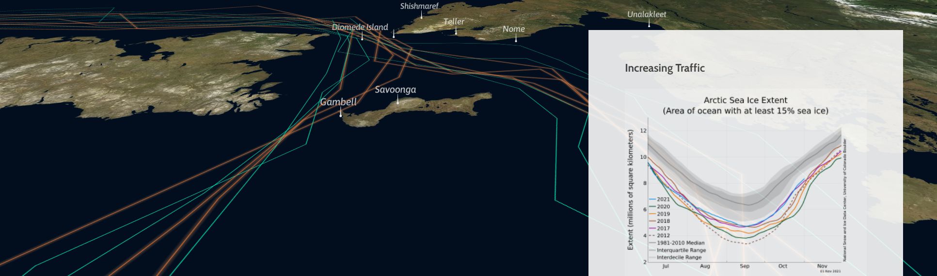
Lucy’s winning map is focused on the impacts of increases in shipping traffic on Northern Indigenous villages along the Bering Strait. Here’s Lucy’s statement about the map:
“As climate change and technological advances enable travel through the Bering Strait, shipping traffic in the region has doubled in the last decade. While this traffic increases, it is important to listen to Inuit cultures about the elevated impacts on their lives and livelihoods. Northern Indigenous people along the Bering Strait, who have relied on seal and fish harvests for centuries, are seeing dramatic changes to the local environment and their traditional way of life. While Native individuals such as Alexandria Abuzanuq Ivanoff have been sharing their knowledge as stewards of the land, these stories have a strong spatial component that can be highlighted through cartographic storytelling.
In this scrolly telling web map, I worked with Ivanoff to select a handful of villages vulnerable to the impacts of these changes. The map begins zoomed out, showing most of the Pacific Ocean, then zooms into these villages to provide the audience with a spatial orientation to the region. Aesthetically, the simple base map serves to highlight the villages and shipping routes without providing extraneous information. The earth tones of the satellite imagery and the dark-blue water contrast with the saturated shipping lanes and seal habitat, promoting these features in the visual hierarchy. This choice made the water, the true setting of the story, a plain background for the dramatic clashes between nature and shipping routes. Cartographically representing the voices of marginalized communities can increase engagement with these important stories. Working with Ivanoff allowed me to design this web map how she wanted her story to be told, and we are excited to continue developing this project in the future.”